1. Introduction
The continuity of rivers, i.e., their free flow without artificial barriers, is a key factor for the hydromorphological and ecological health of aquatic ecosystems (BDS2030 2024). The absence of barriers ensures natural, free movement of water, sediment transport, and migration of aquatic organisms in rivers, which is critically important for maintaining biodiversity and the ecological resilience of river systems (van de Bund et al. 2024).
Disruption of river continuity can lead to significant adverse impacts on river ecosystems, including critical alterations in channel depth, flow regime, channel morphology, sediment erosion and deposition processes, water quality, and thermal conditions (Vörösmarty et al. 2003; Gupta et al. 2012; Fan et al. 2015; Guo et al. 2018; Wang et al. 2018; EC 2022). These impacts, in turn, may lead to population declines or even local extinction of various fish and mammal species. Migratory fish and other aquatic organisms, including mollusks and crustaceans, are often unable to overcome riverine barriers, leading to restricted distribution ranges and significant adverse effects on aquatic biodiversity (Kruk, Penczak 2003; Baudoin et al. 2015; BDS2030 2024).
In the countries of the European Union, the Water Framework Directive is a key piece of legislation that obliges Member States to achieve good ecological and chemical status for all surface water bodies. a crucial step toward improving the ecological status of water bodies (Directive 2000/60/EC).
The removal of artificial barriers is becoming an increasingly common practice worldwide as an effective approach to river ecosystem restoration. The US was the first country to begin removing obsolete and non-functional dams for river flow restoration, fisheries improvement, and flood risk reduction, starting in 1912. Since 1999, more than 1,700 dams have been removed in the country (Bellmore et al. 2016; American Rivers 2023). European countries, particularly France, Denmark, Sweden, and Spain, have also actively begun restoring riverine ecosystems and improving the overall ecological status of water bodies by removing artificial barriers (DRE 2018; Belletti et al. 2020; DRE 2023; Mouchlianitis 2024). In Ukraine, the practice of removing dams and other structures that disrupt natural river processes is still in its early stages. At present, only two projects are known to have contributed to the improvement of river flow in the Cheremosh River basin and the Danube River delta.
In 2019, a project was implemented in the Ukrainian part of the Danube River delta, involving the removal of 10 dams and in-stream embankments on the Kogilnyk, Sarata, and Kagach Rivers in the Danube Biosphere Reserve, which holds international significance. The World Wildlife Fund (WWF) coordinated the project in the Netherlands as part of the Dam Removal Europe initiative for removing decommissioned dams. Thus, the removal of dams on the Kogilnyk, Sarata, and Kagach Rivers contributed to the restoration of natural hydrological processes and the reestablishment of the longitudinal continuity of river flow. This, in turn, led to the creation of approximately 20 km of new habitats along the rivers, including flooded meadows (RDD 2019).
Between 2020 and 2022, WWF-Ukraine, with support from WWF-Netherlands, carried out a project to remove obsolete dams along streams and rivers in the Cheremosh River Basin, within the territory of the Verkhovynskyi National Nature Park. As a result, longitudinal flow continuity was restored along 504 km of river systems (ORP 2022; DRE 2023; Vasylenko et al. 2024).
Ukraine has not yet enacted a specific legal framework or national strategy – similar to the EU Biodiversity Strategy for 2030 – that would govern the restoration of free-flowing rivers and floodplains or regulate the removal of barriers that disrupt the longitudinal continuity of water bodies (EC 2022). Ukraine is nevertheless required to fulfill its international obligations for biodiversity conservation, especially those enshrined in the Convention on Biological Diversity, which provides the foundational principles and objectives for safeguarding and sustainably managing biodiversity. Moreover, the Water Strategy of Ukraine for the period up to 2050 (Verhovna Rada of Ukraine 2022) foresees the phased decommissioning of dams and ponds that are no longer in service, together with a comprehensive inventory of existing hydraulic infrastructure to determine the need for their restoration, maintenance, modernization, or removal. This strategy aims to restore the longitudinal connectivity of small rivers, with a minimum of 5 km targeted for restoration each year.
In Ukraine, river regulation has become a critical ecological problem due to the widespread construction of dams, reservoirs, and other hydraulic engineering structures. The degree of river fragmentation by artificial barriers in the Prut and Siret River basins (within the territory of Ukraine) is extremely high. These river barriers, including dams, culverts, pipelines, sluices, and other hydraulic structures, have been constructed to serve various purposes, including flow regulation, hydropower generation, water level management, erosion control, recreation, water storage for agricultural irrigation and potable use, and flood risk reduction. Nonetheless, alongside their functional advantages, such barriers, especially those in deteriorated or obsolete condition, exert negative effects on aquatic ecosystems (Pasichnyk, Yushchenko 2024).
Because of the lack of structured data on artificial barriers in rivers, the River Basin Management Authority (responsible for the management, utilization, and restoration of surface waters within the Prut and Siret basins) is currently unable to effectively respond to the challenges posed by the extensive proliferation of such barriers, or to develop effective strategies for enhancing the ecological condition of river systems.
Consequently, research on the condition and restoration potential of small-river continuity in the Prut and Siret River basins is of high scientific and practical relevance.
This study aims to address the lack of comprehensive data on barriers in small rivers by collecting and systematizing relevant information, conducting field surveys, and involving local communities in the process of barrier removal. Furthermore, one of the key objectives of this research is to define criteria for prioritizing artificial barriers for removal, thereby facilitating the restoration of longitudinal continuity in small rivers within the Prut and Siret River basins, improving their ecological status, and supporting the sustainable development of aquatic ecosystems in the region.
This study focuses exclusively on artificial barriers that interrupt longitudinal river connectivity. Artificial barriers affecting lateral and vertical connectivity were beyond the scope of this research due to data limitations and the complexity of the required analyses.
2. The study area
The Prut and Siret River basins are transboundary river systems located within the territories of Ukraine, Romania, and the Republic of Moldova. In Ukraine, the combined catchment area of these river basins is 11,430 km2, including 9,320 km2 for the Prut and 2,110 km2 for the Siret, accounting for approximately 36.3% of the Danube River Basin's total area within Ukrainian territory. The Prut River basin is located within the Ivano-Frankivsk and Chernivtsi regions of Ukraine. Its hydrographic network includes 113 rivers with catchment areas larger than 10 km2, as well as two reservoirs with storage capacities exceeding 1 million m3. The Siret River basin is entirely within the Chernivtsi region and includes 20 rivers with catchment areas exceeding 10 km2. There are no reservoirs with a volume exceeding 1 million m3. Together, the Prut and Siret River basins cover 1.9% of Ukraine’s total territory.
The territory of the studied river basins is characterized by an uneven distribution of physical-geographical features, with pronounced differences in relief, moisture conditions, and hydrological regime. The relief of the study area is subdivided into three main zones: mountainous (10%), foothill (40%), and lowland areas (50%). The mountainous and foothill regions are characterized by excessive moisture, while the lowland area is characterized by sufficient moisture. Although spring snowmelt floods occur, the rivers are predominantly characterized by a flood-dominated regime, with frequent and significant floods during the summer–autumn period (which may exceed spring runoff), and also in winter (Surai et al. 2020).
Despite being located in zones of both sufficient and excessive moisture, the river basins have also been affected by an increasing trend of frequent, intense droughts observed in recent decades across Europe, particularly within the Danube River Basin.
Annual monitoring of drought and low-flow conditions in the Prut and Siret sub-basins indicates that the period from 2000 to 2023 was marked by a substantial rise in temperatures and an increase in the frequency and severity of drought and low-flow events. During this period, a shortage of drinking water for domestic use was observed among rural populations, who rely on shallow wells or small streams for water supply. In addition, hydrological observations from 2003, 2011-2013, and 2019-2022 showed that river discharges in the foothill and lowland regions of the study area were below the ecological flow criterion (EC 2015). In 2013, this critical situation extended to the mountainous regions of the basins, where low-flow conditions were also observed (Tysovskyi et al. 2024). These trends in the Prut and Siret sub-basins exacerbate the vulnerability of aquatic ecosystems, compromise the good status of water resources, and affect multiple sectors of water management.
Within the Prut and Siret River basins, 298 surface water bodies (SWB) have been delineated (Fig. 1), of which 249 are natural rivers, and 49 are heavily modified (representing 16.4%) (DAVR 2025). Among the 249 river water bodies, 164 are under 10 km, 91 are between 10 and 20 km, five are between 30 and 40 km, five are between 40 and 50 km, and three exceed 50 km.
Fig. 1.
Surface Water Bodies (SWB) and Heavily Modified Water Bodies (HMWB) within the Prut and Siret River basins.
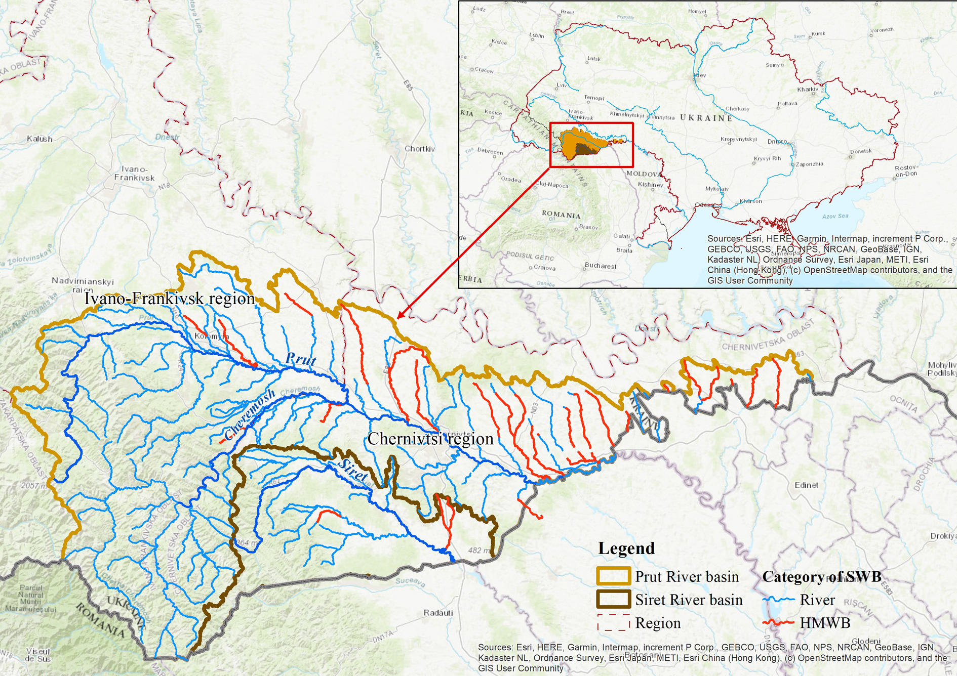
The surface water bodies in the Prut and Siret River basins are classified as heavily modified water bodies (HMWB) for the following reasons: ‒ morphological changes (24 HMWB) ‒ a combination of disrupted water flow continuity and habitat alteration, as well as runoff accumulation (9 HMWB); ‒ a combination of disrupted water flow continuity, habitat alteration, runoff accumulation, and morphological changes (16 HMWB).
There are more than 1,500 ponds in the Prut and Siret River basins. A significant portion of these water bodies has no owners. Most of the in-channel ponds were created between 1960 and 1990 for agricultural purposes, such as irrigation, fish farming, and flood protection. After a prolonged lack of proper management, they are often neglected. Siltation of water bodies, encroachment by wetland vegetation, and the deterioration of hydraulic structures disrupt both the natural flow of rivers and their hydromorphological condition, complicating ecosystem restoration (Pasichnyk, Yushchenko 2024).
3. Methodology and data
Since 2011, Ukraine has been implementing the technical certification of ponds, including the compilation of their physical and hydrological parameters. Furthermore, during 2021-2024, the River Basin Management Authority (RBMA) for the Prut and Siret Rivers conducted an inventory of ponds across their respective basins. As a result of the inventory process, insufficient information was identified regarding the principal parameters of the ponds, the hydraulic infrastructure, and the operational state of the ponds. Furthermore, a significant number of obsolete structures on small rivers have no available records or official documentation. To address this issue, a comprehensive survey was conducted as part of the methodological framework. The survey involved the collection and systematization of data on ownership status, physical characteristics, current condition, and environmental impact of both registered and unregistered barriers within the Prut and Siret River basins.
This survey enabled the first-time digitization of pond inventory data in the Prut and Siret River basins using ArcGIS software. Data for pond locations and parameters, forms of ownership and types of use, the presence of official documentation, and the condition of hydraulic structures were used (Costa, Vieira 2023).
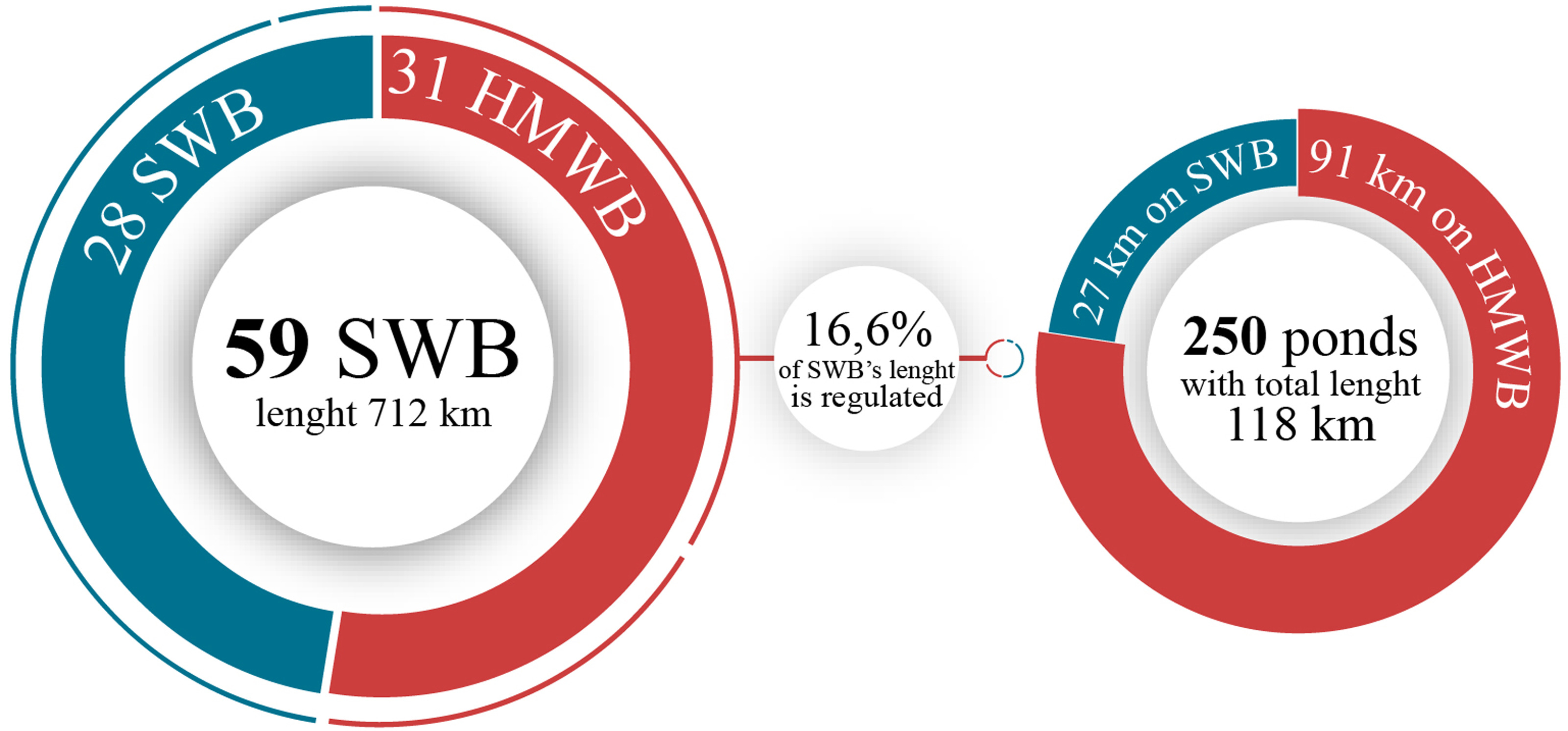
There is a total of 1,864 ponds in the Prut and Siret River basins (covering the Chernivtsi and Ivano-Frankivsk regions). Among these, 1,400 are in-channel ponds, while the remaining 464 are floodplain ponds, gully ponds, and off-channel ponds, including flooded quarries and small artificially excavated water bodies serving local needs. Within the studied basins, 82% of the in-channel ponds are located on rivers shorter than 10 km, while 250 ponds (the remaining 18%) are constructed on 59 delineated SWB (on rivers longer than 10 km). Thus, 16.6% of the length of these SWB is regulated (see Fig. 2).
Fig. 2.
The total number and regulated length of surface water bodies (SWB) and heavily modified surface water bodies (HMWB) affected by in-channel ponds within the Prut and Siret River basins.
To support the planning, organization, and implementation of barrier removal measures, a step-by-step algorithm has been developed (Fig. 3). This algorithm is intended to assist the River Basin Management Authorities of Ukraine in systematizing and compiling all available data on in-channel barriers, as well as facilitating the development of management decisions aimed at improving the ecological status of surface water bodies, restoring the hydrological regime, and rehabilitating the hydromorphological characteristics of these water bodies.
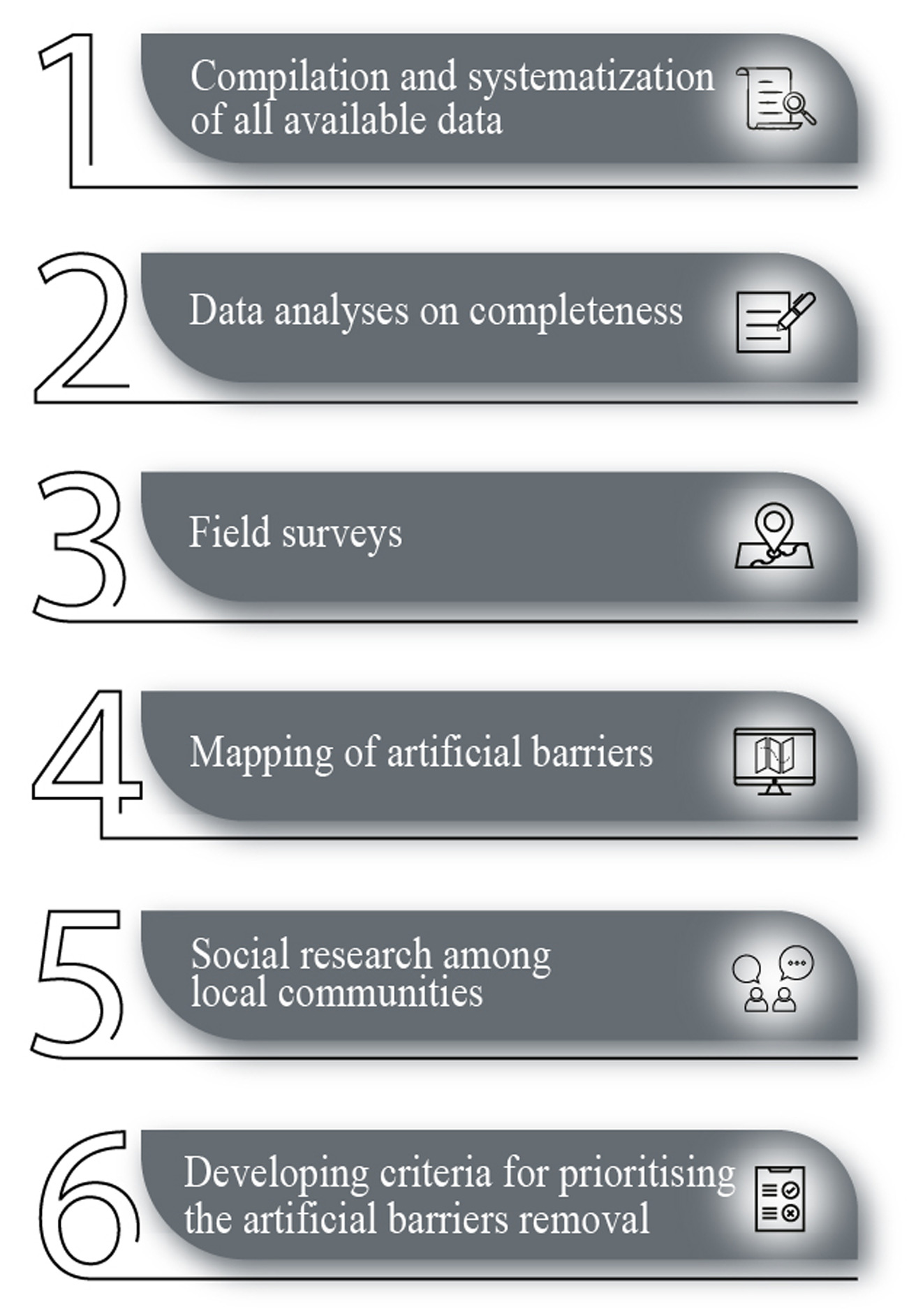
This algorithm systematizes all procedural steps involved in the implementation of governmental and private initiatives aimed at restoring free-flowing rivers, specifically through the removal of artificial barriers (EC 2021):
Compilation and systematization of information from archival sources, inventory records, and data obtained through cooperation with local communities and nature reserve authorities (if available) concerning artificial barriers within the studied river basins. Sending official letters to local communities and national nature parks requesting information on the presence of artificial barriers on rivers within their area of responsibility. Request for completing a standardized data collection form with the following fields: river name, barrier name and type, geographic coordinates/location, owner, administrative affiliation (community), and photographs of the barrier. Conducting online meetings and consultations to provide information on the types of artificial barriers, their impact on river ecosystems, the importance of identifying such barriers, and the implementation of measures for their removal, etc.
Analysis of existing data regarding the completeness of information on artificial barriers in surface water bodies.
Field surveys during which information is verified, updated, or collected concerning artificial barriers that are managed by local communities or nature reserve authorities; have no registered owner or user; or for which information is completely lacking despite their presence. During the field surveys, the following activities are conducted:
identification of river barrier sites: including river name, geographic coordinates of the site, and date of observation;
characterization of river barriers, including typology (artificial structures, litter), size parameters, and assumed origin;
analysis of the physical condition of the barrier and its potential influence on ecological processes;
photo and video recording.
All collected information is recorded in field protocols.
Mapping of artificial barriers, i.e., the graphical representation of all available data, including descriptive information for each object, using ArcGIS;
Carrying out social research among local communities regarding river restoration through the removal of barriers that are unnecessary, ineffective, outdated, or pose potential risks. An individual questionnaire is developed for each community, containing information on a specific artificial barrier whose removal is planned to be assessed. The questionnaire included a series of questions concerning the river or stream flowing within the settlement, its condition according to the respondent’s opinion (rated from excellent to very poor), the reasons for poor condition if rated below good (selected from provided options), and measures that could improve the river’s condition (selected from provided options). In addition, the questionnaire proposes specific measures to improve the river’s condition (such as dam removal, riverbed revitalization, etc.) and records the respondent’s attitude regarding these measures. The target audience of the study includes residents of the relevant communities, local authority representatives, and other groups potentially affected by the implementation of measures to remove artificial barriers that obstruct the free flow of rivers for their restoration (Tonitto, Riha 2016).
Developing or applying criteria to generate a prioritized list of identified artificial barriers for removal. Each artificial barrier is assessed for compliance with a set of prioritization criteria. The final priority level is determined by the cumulative score and is classified as high, medium, or low for removal.
4. Results
The collection of preliminary information on barriers in the basins of the Prut and Siret rivers (Chernivtsi and Ivano-Frankivsk regions) started with communication and coordination with local communities and national nature parks. Within the boundaries of the researched region, there are 72 local communities and three national nature parks (Verkhovyna, Vyzhnytsia, and Cheremosh).
As a result of cooperation and interaction with local communities in the Ivano-Frankivsk and Chernivtsi regions, 48 response letters were received from communities and one letter from the Cheremosky National Nature Park (with photographic documentation) about artificial barriers on rivers in the Prut and Siret River basins. Thus, a total of 33 barriers were identified in the rivers, 20 artificial and 13 natural. Data concerning the location and characteristics of these barriers were collected.
The process included searching archival information at the River Basin Management Authority, analyzing inventory data on water bodies and hydraulic structures collected between 2021 and 2024, reviewing information contained in the measures programs of the Danube River Basin Management Plan (DAVR 2025), and extracting data from river and pond passports, topographic maps, and scientific references (Palamarchuk, Zakorchevna 2006; Hrebin et al. 2014). As a result, a list of ownerless water bodies (ponds) with hydraulic structures in poor or emergency condition was compiled, and the owners of pond hydraulic structures were identified. If the owners of the barriers cannot be identified, Ukraine has developed an algorithm for transferring them to the ownership of local communities (WWF Ukraine 2019).
Moreover, a visual analysis of the study area was conducted using the Google Maps platform, enabling comparison between the current situation and the existing inventory data on water structures.
According to the analysis, mountainous regions are predominantly affected by historical splash dams (wooden dams with stone foundations used for log driving), remnants of bridge piers destroyed by floods, and small-scale dams. Meanwhile, foothill and lowland areas of the Prut and Siret River basins are characterized by small river segments modified through pond cascades created by hydraulic infrastructure.
Based on the information received from local communities and existing datasets, a list of artificial barriers was compiled for which additional data needs to be collected during further field surveys.
Fifteen routes were developed for conducting field surveys. Field surveys were conducted in collaboration with local community representatives. During these surveys, field protocols were completed for each artificial barrier. If cascades of barriers were present on the river, the distance between them (in km) was recorded.
Additionally, during field surveys, the general state of the river channel was assessed. Special focus was given to sections of the river with marsh or woody vegetation, which can significantly affect water flow and reduce channel connectivity for aquatic organisms.
Moreover, social surveys were conducted during the fieldwork in the form of completing the developed questionnaires. The results were summarized, and aspects requiring attention for further work on specific sites were identified. For example, accounting for flood protection measures or conducting additional information campaigns, etc.
Such surveys helped assess community attitudes, readiness to improve local areas, and understanding of water protection and environmental conservation measures, especially regarding the enhancement of the ecological condition of surface water bodies. The involvement of local communities in discussions of proposed measures and initiatives helped establish cooperation, gave them a sense of engagement, and provided them with the opportunity to influence river restoration processes (Marushevska 2024).
Based on the water bodies inventory, a total of 79 ownerless ponds were identified across 10 local communities, and the hydraulic structures were assessed as being in poor or emergency condition. Among them, two objects were identified based on the list of measures outlined in the Danube River Basin Management Plan: (1) the reconstruction and dismantling of a hydraulic structure on the Hlynytsia River in the village of Drachyntsi (Mamaivtsi Local Community), and (2) the removal of a weir on the Storozhynets River in the village of Bila (also within the Mamaivtsi Local Community).
Based on the collected and systematized data, a functional map was created using the ArcGIS geographic information system, serving as a tool for effective spatial analysis and visualization of barriers within the Prut and Siret River basins. The map includes additional attributes including the type of barrier (such as dam, sluice, engineered structure, reinforced concrete debris), its size characteristics (length and width), geographical coordinates, current technical condition (good, poor, or unsatisfactory), recommended actions (e.g., removal), ownership or leaseholder information, and supporting photographic documentation to improve visual interpretation.
After field surveys and clarification of spatial and attribute data, some artificial barriers were excluded from the final list (20 artificial barriers). Such objects include historically significant barriers that are exempt from removal. Several barriers were identified as road crossings for which reconstruction, rather than removal, is considered appropriate.
Thus, the RBMA, in collaboration with local communities, identified 59 artificial barriers within the rivers of the Prut and Siret basins in the Ivano-Frankivsk and Chernivtsi regions (Fig. 4) (Pasichnyk, Yushchenko 2024).
Fig. 4.
Distribution of identified barriers by the Prut and Siret River basins (a) and their distribution based on types (b).
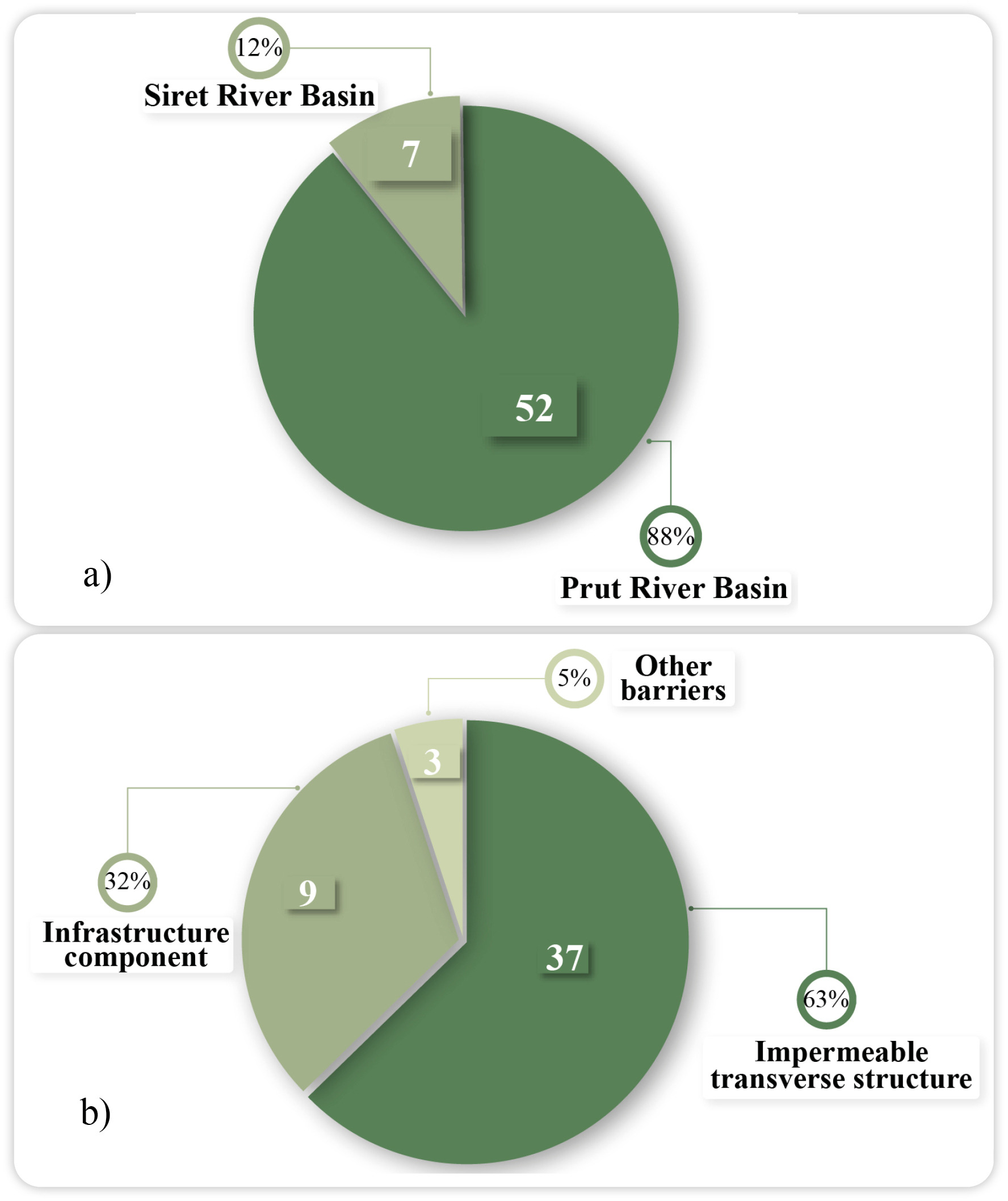
To simplify the analysis, the artificial barriers identified in the Prut and Siret River Basins were divided into the following groups (Fig. 4b):
Impermeable transverse structure (splash dam, dam).
These structures block the river channel and prevent the free flow of water to regulate water flow, accumulate water upstream, or redirect the flow. Such dams are often used to construct reservoirs, provide irrigation, supply water, or generate hydropower. Splash dams (wooden dams), as historical structures, were primarily used to raise the water level in rivers to float logs downstream to sawmills. Such structures significantly alter the natural hydrological regime of the river, contribute to upstream silt and sediment accumulation, reduce flow velocity, and affect nutrient distribution in the water. This leads to changes in aquatic flora and fauna, a decrease in biodiversity, and can result in the loss of species dependent on fast flow velocity.
Infrastructure component (remnants of construction structures, bridge piers, culvert crossings).
This group includes remnants of bridges, concrete blocks, foundations, or other infrastructure elements introduced into the riverbed after construction or reconstruction. It also includes bridge piers and culverts that are part of the transport infrastructure. Such elements create physical obstacles to the natural flow of water, induce turbulence, and contribute to the accumulation of sediment and fine-grained deposits near the structures. This can lead to bottom and bank erosion, alter the flow direction, and create whirlpools, which complicate the migration of fish and other aquatic organisms. Furthermore, these elements can become sites of debris and other natural material accumulation, further increasing the impact on the river ecosystem.
Other barriers.
These barriers are primarily anthropogenic waste and other litter that accumulates in the riverbed. They can result from human activity. Such barriers create blockages that alter the flow direction, slow down water movement, and contribute to sediment accumulation, leading to flooding of adjacent areas, deterioration of water quality, and lower dissolved oxygen levels. Such barriers can also create favorable conditions for the growth of pathogenic microorganisms.
The removal of barriers that disrupt the free flow of rivers is a complex and multi-stage process, which includes careful planning, environmental impact assessments, public consultations, river ecosystem studies, etc. In addition, this process requires significant resources, both financial and human, so efforts should be primarily directed toward barriers whose removal will provide the greatest ecological and social benefits (Beechie et.al. 2008). For this purpose, criteria for prioritizing the removal of artificial barriers have been developed. When prioritizing the removal of artificial barriers, various factors must be considered, including water-use needs, protection against potential hazards to the population and adjacent territories, and the restoration of the river's free flow (Jumani et al. 2023).
The following criteria have been developed for prioritizing the removal of artificial barriers (Fig. 5):
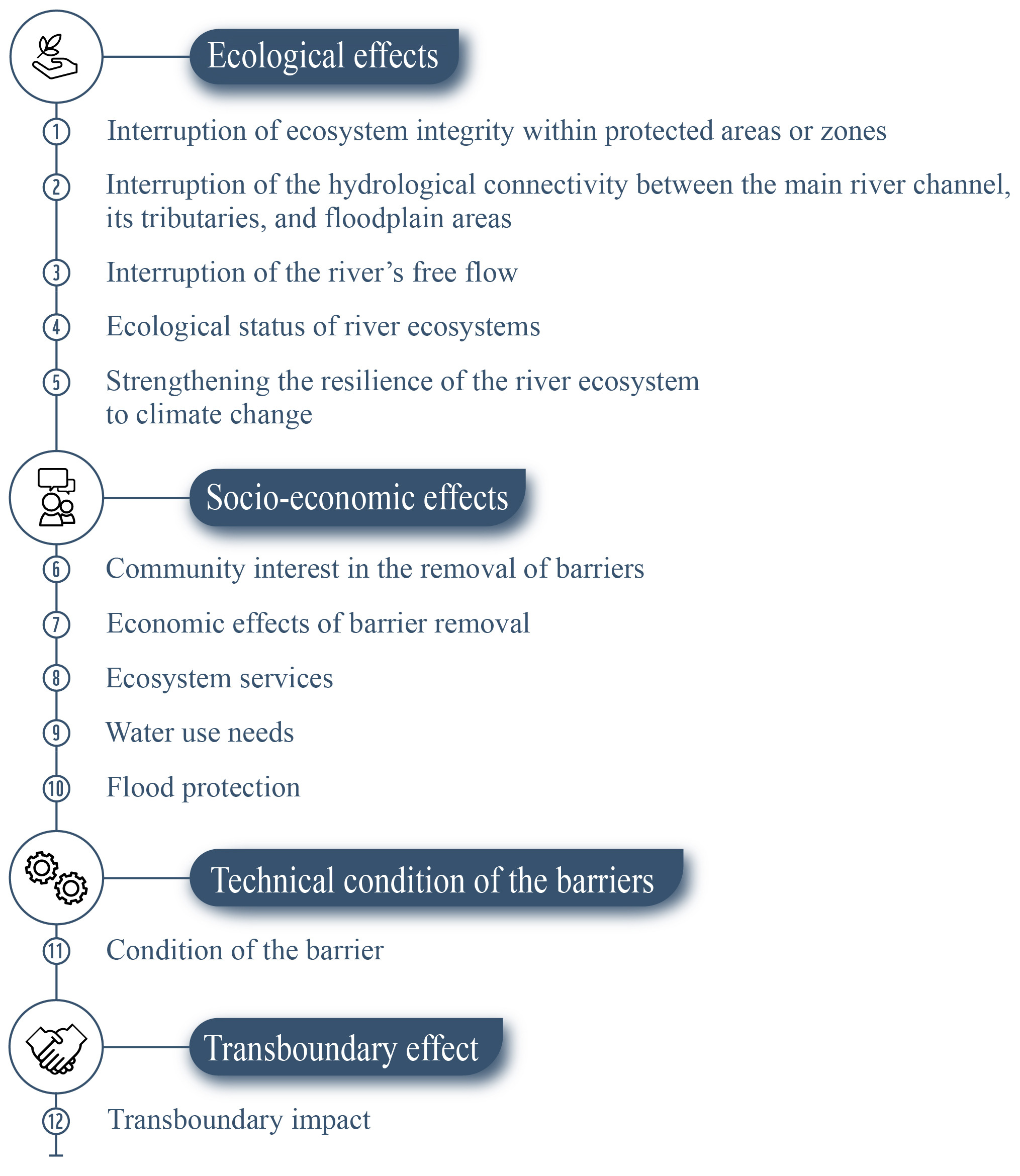
Ecological effects (Hart et al. 2002; Higgs 2002):
− Interruption of ecosystem integrity within protected areas or zones. The placement of barriers within reserves, national parks, Emerald Network sites, or other protected areas interrupts the natural ecological status that these areas aim to maintain. Such barriers can contribute to the loss or decline of various flora and fauna species, especially rare ones.
− Interruption of the hydrological connectivity between the main river channel, its tributaries, and floodplain areas – the presence of artificial barriers leads to a reduction in water flow, degradation of floodplains, and the surrounding ecosystems. The removal of such barriers will restore the natural hydrological regime and floodplain ecosystems and will contribute to the conservation of wetlands.
− Interruption of the river’s free flow – artificial barriers alter the natural hydrological regime of rivers, restrict the migration of biota both upstream and downstream, and modify their habitats and spawning grounds. The removal of barriers will increase dissolved oxygen, reduce stagnation processes (and, consequently, eutrophication), restore the natural transport of sediments (preventing siltation), and help re-establish the water’s natural thermal regime, which has been altered by reduced flow velocity, etc. In addition, removing such barriers will restore migration pathways for biota, increase their populations, and improve their habitats.
− Ecological status of river ecosystems – includes physicochemical, biological, and hydromorphological conditions, alterations in which have a direct impact on water use and the formation of habitats for aquatic biota.
− Strengthening the resilience of the river ecosystem to climate change – if rivers are in their natural or near-natural condition (with free flow), they are better able to adapt to climate change.
Socio-economic effects – includes improving the living conditions of local people, increasing the efficiency of water resources use, promoting investment, and creating new opportunities for communities:
− Community interest in the removal of barriers – local communities and stakeholders may oppose the removal of artificial barriers because of concerns about potential flooding of their lands, restrictions on water use and fish farming, the historical value of the structures, or the loss of recreational water objects (ponds), etc. The consent of local communities is crucial for the removal of such barriers. This criterion has the greatest weight in prioritizing the removal of artificial barriers.
− Economic effects of barrier removal – enhancement of the investment attractiveness of water objects, providing additional workplaces, development of new places for recreation and tourism, restoring fisheries, and other related benefits.
− Ecosystem services – removing barriers from the river channel is an important step toward the restoration and enhancement of ecosystem services (such as water regime regulation, biodiversity support, water quality improvement, etc.), which ensures the sustainable use of natural resources and contributes to improved quality of life.
− Water use needs – the removal of artificial barriers will increase the river's water level and improve water supply. Consequently, water quality will improve, which is important for communities that use the river water for drinking, domestic, and industrial needs.
− Flood protection – if artificial barriers (such as dams, weirs, or dykes) are used to protect adjacent areas, especially within settlements, from flooding, their removal priority is reduced.
− Technical condition of the barriers. When determining the priority of removing artificial barriers, their technical condition should be taken into account. The barriers may be outdated, partially or fully damaged by prolonged use, natural disasters, or lack of proper maintenance, and no longer serve their original functions (flow regulation, water retention, flood protection, etc.). Such artificial barriers may pose a risk of structural failure or breach, which could lead to significant damage and threaten public safety. The removal of such barriers may lead to economic benefits by reducing maintenance and repair costs. It can also lower the risk of structural failure and, as a result, help prevent potentially serious accidents and protect downstream communities and property from possible flooding impacts. Unfortunately, information on the operational periods of the hydraulic structures is often unavailable, which complicates the assessment of their removal priority. Barriers in poor condition or with gaps often cause irregular and inefficient sediment trapping, leading to unstable sediment accumulation upstream from the structure. This uneven accumulation disrupts sediment continuity, alters channel morphology, and can result in greater erosion and ecological degradation both upstream and downstream than with barriers in good condition.
− Transboundary effect. This criterion accounts for the transboundary impact of removing artificial barriers. The removal of artificial barriers will enhance cooperation and coordination among countries, reduce the number of transboundary water-related conflicts, and increase the flow of transboundary rivers. This criterion applies to rivers that flow through several countries. In this case, this criterion is necessary for the Prut and Siret River Basins, because some of the identified artificial barriers are situated on rivers that originate in Ukraine and subsequently flow into the Republic of Moldova. In addition, these barriers are situated near the national borders and limit the inflow of water into Moldova, causing downstream water shortages.
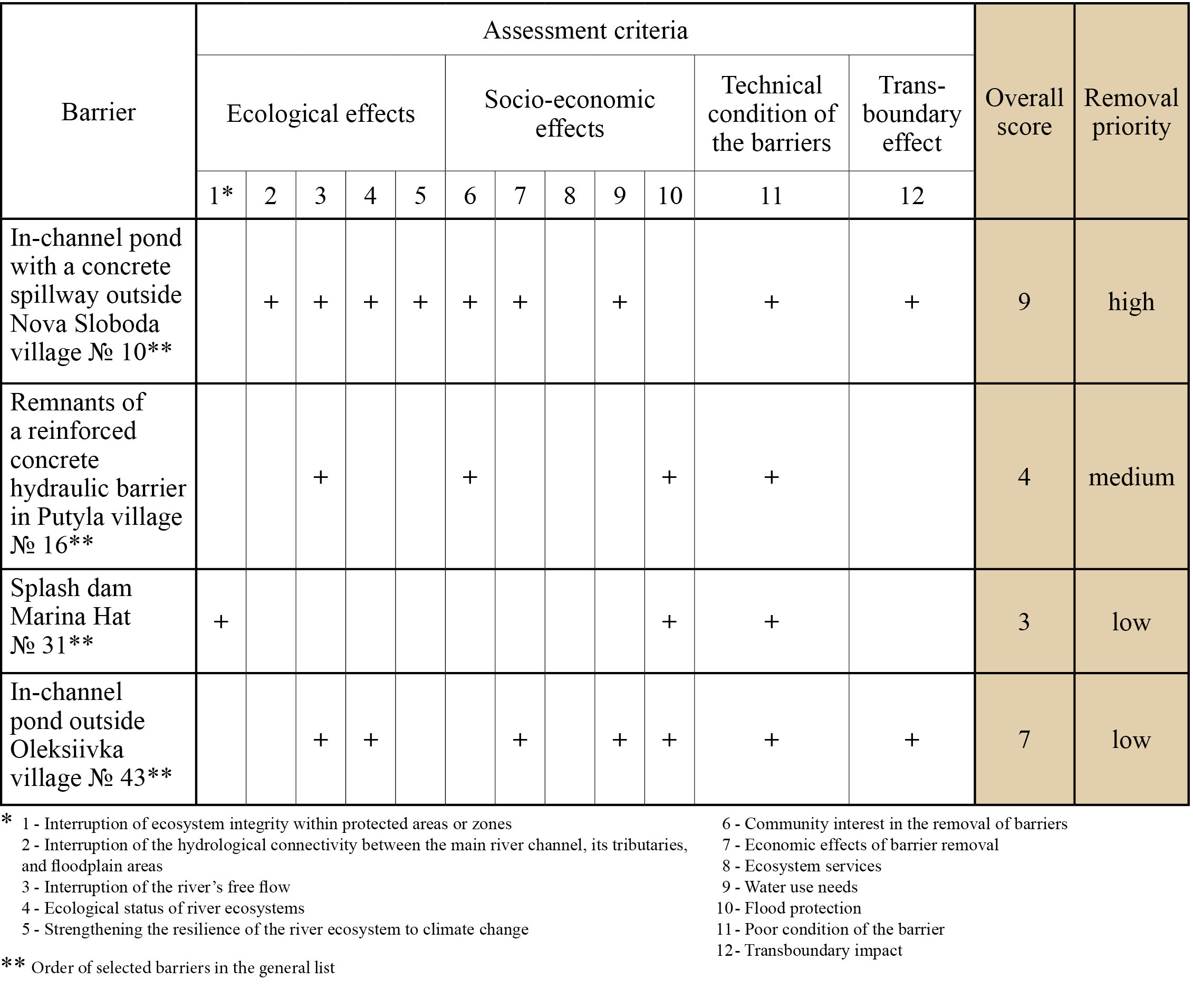
Since no formal scientific methodology for prioritizing barrier removal has yet been developed in Ukraine, an informal, expert-judgment-based method was used to classify the selected barriers by removal priority (de Leaniz, O'Hanley 2022). Thus, a table listing 59 selected artificial barriers in the Prut and Siret River basins was created using Microsoft Excel.
The removal priority of artificial barriers in the river channels of the studied basins was ranked based on the significance of their removal for local communities and the restoration of river ecosystems: high, medium, or low. Each removal priority is based on an assessment of the barrier’s impact according to criteria that include ecological, socio-economic, technical, and transboundary effects.
Each barrier was evaluated against the prioritization criteria, with higher priority assigned to those that satisfied more criteria.
Barriers with an overall score above 7 were categorized as high removal priority, those with scores between 4 and 6 as medium removal priority, and barriers meeting fewer than 4 prioritization criteria were ranked as low removal priority. If the removal of an artificial barrier did not receive support from local communities, it was automatically assigned to the low-priority category, regardless of its overall score (Fig. 6).
Fig. 6.
Examples of removal priorities for identified artificial barriers in the Prut and Siret River Basins.
Based on the assessment and systematization of the identified artificial barriers, a classification map of artificial barriers by removal priority was created in ArcGIS for the Prut and Siret River Basins (Fig. 7).
Fig. 7.
Classification map of artificial barriers by removal priority in the Prut and Siret River Basins.
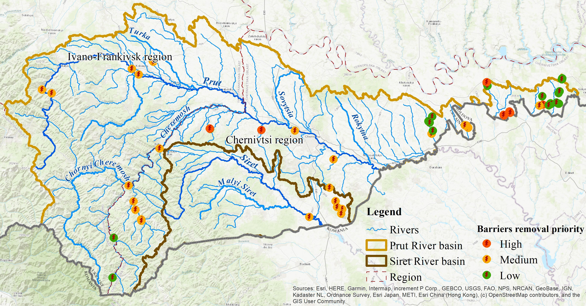
Figure 6 illustrates part of the developed table, showing barriers assigned a high, medium, or low removal priority.
Eleven obstacles (marked in red on the map) have been assigned a high removal priority due to their significant negative impacts on river ecosystems, including biodiversity disruption, alterations in the hydrological regime, and deterioration of the ecological condition of river systems, etc. The removal of these barriers is critically important, as they show maximum alignment with all relevant ecological and socio-economic criteria, including the support of local communities.
Twenty-eight obstacles have been assigned a medium removal priority (marked in orange on the map), as they have a lower negative impact on the ecosystem: hydromorphological conditions are altered, but chemical and biological states do not have significant changes, and the hydrological 1connection between the main river, its tributaries, and floodplain areas is not disrupted. The removal of these barriers will not bring any economic benefits, but it will contribute positively to the health of the river ecosystem. Local communities have also supported the removal of the barriers in this group.
Twenty obstacles have been assigned a low removal priority (marked in green on the map). Their removal is currently unlikely. The main reason is the low level of support for the removal of these barriers among the local population. Despite their negative impact on the river ecosystem (disruption of hydromorphological and biological conditions) and the potential for significant economic benefits from their removal, implementing such measures currently requires further engagement with local communities to enhance environmental awareness. This group mainly includes hydraulic structures of ponds, which in the future could be leased and used to generate revenue for local community budgets.
Thus, in the Prut and Siret River Basins, high removal priority was assigned to the dams and hydraulic structures of nine ownerless ponds, an old bridge in critical condition, and a road crossing the pond bed.
In the future, additional research will be conducted on these artificial barriers that disrupt the free-flowing rivers. As part of this research, an assessment of the hydromorphological and hydrobiological status of the water bodies where the barriers are located will be carried out, and a social survey will be conducted within the local communities. The research will allow us to identify the highest priority objects within the studied basins, the removal of which will help restore the natural free flow of rivers and improve their ecological status.
5. Conclusions
A structured algorithm for the management of small rivers has been developed, focusing on the restoration and ecological enhancement of river ecosystems by removing in-channel barriers and obsolete hydraulic structures that no longer serve their intended function or require reconstruction. The Prut and Siret River basins in Ukraine served as case study areas for the application of this approach.
In December 2024, Ukraine approved the River Basin Management Plans for the country’s main river basins for the period 2025-2030. These plans include Programs of Measures aimed at improving and restoring the hydrological regime and morphological characteristics in cases of disrupted river continuity, hydraulic disconnection between river channels and their floodplains, hydrological alterations, and modifications to river morphology. The implementation of these measures in Ukraine faces challenges due to a lack of appropriate practices and requirements for their execution, as well as the absence of proper project documentation for detailed design.
The absence of current, systematized digital data on artificial barriers (including dams, hydraulic installations, and crossings) poses a significant challenge to the assessment and mitigation of their impact on river ecosystems. Therefore, a geospatial layer with attribute data (including barrier characteristics, technical condition, and location) was created in ArcGIS, containing information on 1,864 ponds in the Prut and Siret River basins. It is important to highlight that river regulation within these basins through the construction of hydraulic structures, particularly on approximately 1,400 in-channel ponds, has caused channel siltation and alteration of natural river conditions. These alterations constitute a major factor contributing to the deterioration of the rivers’ ecological status.
To fulfill the aims of the study, comprehensive research was conducted in collaboration with local communities in the Prut and Siret River basins, with the objective of identifying and mapping all barriers that disrupt river continuity, based on both archival sources and field data. The research included the identification and characterization of barriers, encompassing their typology, locations, intended functions, size parameters, ownership, and current technical condition. An interactive GIS-based map was created, compiling data on 79 hydraulic structures in ownerless ponds within 10 local communities.
Additionally, a set of criteria was developed as the basis for a prioritized list of artificial barriers for removal. This list will assist River Basin Management Authorities and local communities in implementing measures to restore the hydrological regime and the free flow of rivers, thereby contributing to the achievement of ecological objectives established by national legislation. Criteria for determining the removal priority (high, medium, low) of identified barriers are based on ecological, socio-economic, and transboundary effects, as well as the technical condition of the structures.
The application of these criteria identified 11 barriers with high removal priority in the Prut and Siret River basins. This means they are highly recommended for removal due to their significant impacts on water flow and ecosystem health. The selection is justified by local communities' interest in removing these artificial barriers, their significant environmental risks, and their poor technical condition. Establishing connections with local communities and discussing the impact of artificial barriers on local ecosystems not only helps refine information about the study objects but also provides residents' support in accompanying and participating in surveys conducted jointly with experts on the rivers. Social surveys of local communities help to understand their attitudes and willingness to improve their territories. They also provide an opportunity to develop awareness campaigns aimed at enhancing community understanding of water protection and environmental conservation measures, particularly regarding the improvement of the ecological status of surface water bodies.
Local community support is a crucial factor in choosing which artificial barriers to remove that disrupt the free flow of rivers. This factor should be taken into account in the assessment of removal priorities.
All data compiled in this research will provide a foundation for subsequent decision-making processes: − These data will serve as a crucial foundation for planning river ecosystem restoration measures, including the removal of obsolete or unused structures. − These data will support monitoring of water bodies’ conditions, allowing for tracking the effectiveness of restoration and renaturation activities.
The priority list of artificial barriers identified for removal in this study was largely determined through expert judgment rather than a strictly scientific approach. This recommended list should not be interpreted as a call for immediate action, as the removal of barriers impeding free-flowing rivers is a complex, multi-stage process requiring comprehensive analysis, strategic planning, technical execution, and post-removal monitoring.
This research is the first such initiative in Ukraine and is expected to evolve further. Moreover, this practice will serve as a valuable tool for engaging local communities, helping to raise awareness of the importance of removing barriers that no longer fulfill their intended function and exert only negative impacts.
