1. Introduction
The climate of Nigeria spreads across the distance of 1,100 km of the south and the north of the country, thus, covers many of the climatic belts of West Africa (Iloeje 1981). This climate is dominated by the influence of three wind currents that include: the tropical maritime (mT) air mass, the tropical continental (cT) air mass and the equatorial easterlies (Ojo 1977). The first air mass originates from the southern high-pressure belt located off the Namibian coast and, in its path, picks up moisture from over the Atlantic Ocean and is thus wet. The second air mass (cT) originates from the high-pressure belt north of the Tropic of Cancer. This latter air mass picks up little moisture along its path and is thus dry. These first two air masses (mT and cT) meet along a slanting surface called the Inter Tropical Discontinuity (ITD). The third air mass (equatorial easterlies) is a rather erratic cold air mass, which comes from the east and flows in the upper atmosphere along the ITD.
Adejuwon (2012) noticed that, apart from the contribution of ITD to rainfall distribution in South-western Nigeria, other factors controlling rainfall in the area include the ocean-atmosphere interaction, relief, line squall and the local features. Ifabiyi and Omoyosoye (2011) also observed that rainfall within the tropical regions is highly variable, and this accounts for the uneven distribution of rainfall frequency, amount, duration, density and some other variables throughout Nigeria. In another study, Odjugo (2010) observed that there has been a statistically significant increase in precipitation and air temperatures in vast major cities in Nigeria. Eludoyin (2009) studied monthly rainfall distribution in Nigeria between 1985-1994 and 1995-2004 and noticed some fluctuations in most months over the decades. Igwenagu (2015) also observed this fluctuation as measures of irregularity in the patterns of rainfall in Enugu state, Nigeria. She observed a clear decline in patterns of rainfall from the year 2000 to 2001 and a slight increase from 2002 to 2003. The trend increased remarkably from 2004 to 2010 with a peak being observed in 2006. Ayansina and Ogunbo (2009) investigated the seasonal rainfall variability in the Guinea savannah part of Nigeria and concluded that rainfall variability continues to be on the increase as an element of climate change. Olaniran (2002) opined that the rainfall onset (start of rain) has been progressively delayed since 1968 over southern Nigeria and this has been further corroborated by a significant decline in April rainfall.
In Benin City, Nigeria, Ikhile and Aifesehi (2011) observed that rainfall in the decade 1961-2000 exhibited distinct variations, with the first decades showed double maxima of rainfall with an August break. In the fourth decade (1991-2000), the August break was absent with the August months recording generally higher rainfall values than all the other decades. This means that the normal trend was reversed in this decade. Even the December months were very wet. January was generally the driest month with a total of 682 mm of rain between 1960 and 2000. July was the wettest month with a total of 14 975 mm of rainfall between 1961and 2000.
However, Babatolu (2002) noticed that rainfall distribution of Ondo during the period of study (1961-2000) showed wide variability. The highest rainfall figure in the decade was recorded in 1963 (2,441 mm) and the lowest was recorded in 1997 (1,217 mm). The rains decreased generally in the last decade (1991-2000), meaning that rainfall distribution along the axis of Ondo and Benin is quite varied (Ikhile, Aifesehi 2011). However, Olaniran (2002) agreed that the likelihood of flooding in the southwestern Nigeria is as a result of abundant of rainfall received by the region especially with Ondo and Ado flooding in 1999. He further explained that flooding is common in these areas in the month of July as evidence that the area is experiencing normal rainfall but not in rainfall frequency.
Olaniran (2002) concluded that there has been a progressive early retreat of rainfall over Nigeria for up to half a century now, and that this is consistent with this pattern of decline in the frequency of rainfall. This pattern is as a result of noticeable changes in the beginning and end of the rainy season in recent times in Nigeria. Odjugo (2010), Oguntude et al. (2012) separately reported that spatial and temporal variations in temperature were noticed in Nigeria where air temperature has been on the increase gradually since 1901 and with a noticeable increase from 1970. Igwenagu (2015) found that the average annual rainfall in coastal areas of Enugu is around 2000 mm because of heavy rainfall during the rainy season.
The coastal regions of West Africa (areas around Calabar) are a continuously rainy area, where there are some seasonal variations in rainfall but where no real dry season occurs. This is followed by a region where two rainy seasons and two dry periods alternate. The length and intensity of the two major rainy and two dry seasons are rarely the same. In the northern part of West Africa, only a short rainy season and a long dry season occur. Rainfall decreases, both in duration and amount, from the coast to the interior except where altitudinal effects create islands of higher rainfall (e.g. Jos Plateau). The coastal areas receive over 4000 mm spread over 8-10 months while the extreme north receives less than 250 mm spread over 3 to 4 months. The length of each season however varies from place to place depending on the proximity from the sea (Oyewo 2005)
Wind plays a great role in the formation of rainfall in Nigeria; the direction of wind blow determines the rainfall pattern, which majorly in moist-rich environments with moist air mass, thus leading to rainfall. Moreover, the process of adiabatic cooling and condensation is an essential factor of rainfall (Bravar, Kavvas 1991; Christopherson 2012). As it relates to other element of weather, wind direction has been changing with climate change. The direction of wind has been shifting from normal to abnormal over particular periods of time (Christopherson, Birkeland 2017; Davy et al. 2018). In some prevailing conditions, changes in wind pattern can bring about rainfall or drought conditions. Thus, observing the direction of wind could help in determining the nature of rainfall over a period of time.
The selection of Southwestern Nigeria for this study enhances the understanding of climate patterns in most of the related environment in Nigeria and in the world at large. This current research examines the analysis of rainfall and wind-flow patterns in Southwestern Nigeria with a view to determining the best way to adapt to the impact of climate change on rainfall fluctuation.
2. Materials and methods
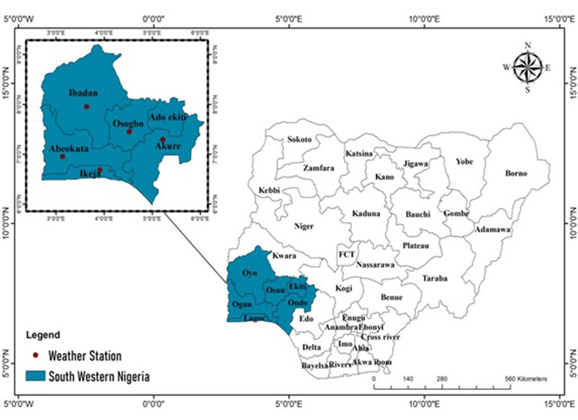
Southwestern Nigeria is a prominent region in the country. It is located roughly between longitudes 2°31' and 6°00' East and latitudes 6°21' and 8°37' North. This region comprises six states and their capitals: Lagos (Ikeja), Ogun (Abeokuta), Oyo (Ibadan), Osun (Osogbo), Ondo (Akure), and Ekiti (Ado-Ekiti) (Fig. 1). This location is dominated by the Yoruba-speaking people of Nigeria with some high levels of related indigenous socio-economic activities that include agriculture. The agricultural practices are dependent of the rain-fed cultivation of both cash and food crops. However, the vegetation and soil types vary significantly as it depends on prevailing environmental dynamos.
Rainfall and wind flow data from the study area were collected from five major weather stations across Ikeja, Ibadan, Abeokuta, Osogbo and Akure between 1971 and 2020. The selection of the study locations and the observed data periods were based on the availability of/and accessibility to recorded climate data. These seasonal climatic data were subjected to descriptive statistics with their results presented through charts and wind flow maps. Geographical Information System application (Arc GIS 10.1) was used to map out the patterns of wind direction within the study area. The application's capability to perform image interpolation and rasterization is one of its relevant key components in this study. The interpolation capability of GIS helped in adjusting image resolution and quality, while rasterization converted vector graphics into a pixel-based format. The obtained mean annual value of the climatic variables was used to map out the proportion of the variable in each weather station such that the thicker in colouration obtained, the higher the concentration of the variable in the station. Wind direction in this study was typically reported using the cardinal directions (north, east, south, west) and their intermediate points.
3. Results
3.1. Seasonal rainfall data in the Southwestern Nigeria
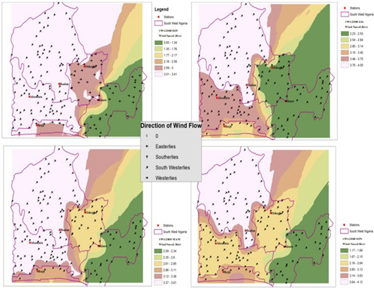
It was observed that Southerly, Westerly and South-westerly wind streams were the dominant wind flow pattern over the entire study area. These wind flows encountered some micro- and mesoscale motions that often refer to disturbances or perturbation in the region. The disturbances exerted measures of influence on rainfall amounts recorded over four major seasons considered in this study. These seasons are: December-January-February (DJF), March-April-May (MAM), June-July-August (JJA) and September-October-November (SON) (Fig. 2). The mean seasonal rainfall amount in the decades during the period of study (1971-2020) was presented in Table 1. The South-westerly monsoon is moisture laden and hence a rain- bearing wind which blows inland from the Atlantic Ocean; as it blows inland, its influence on producing rain weakens. The weakness of this wind aggravates during the December, January and February (DJF) months.
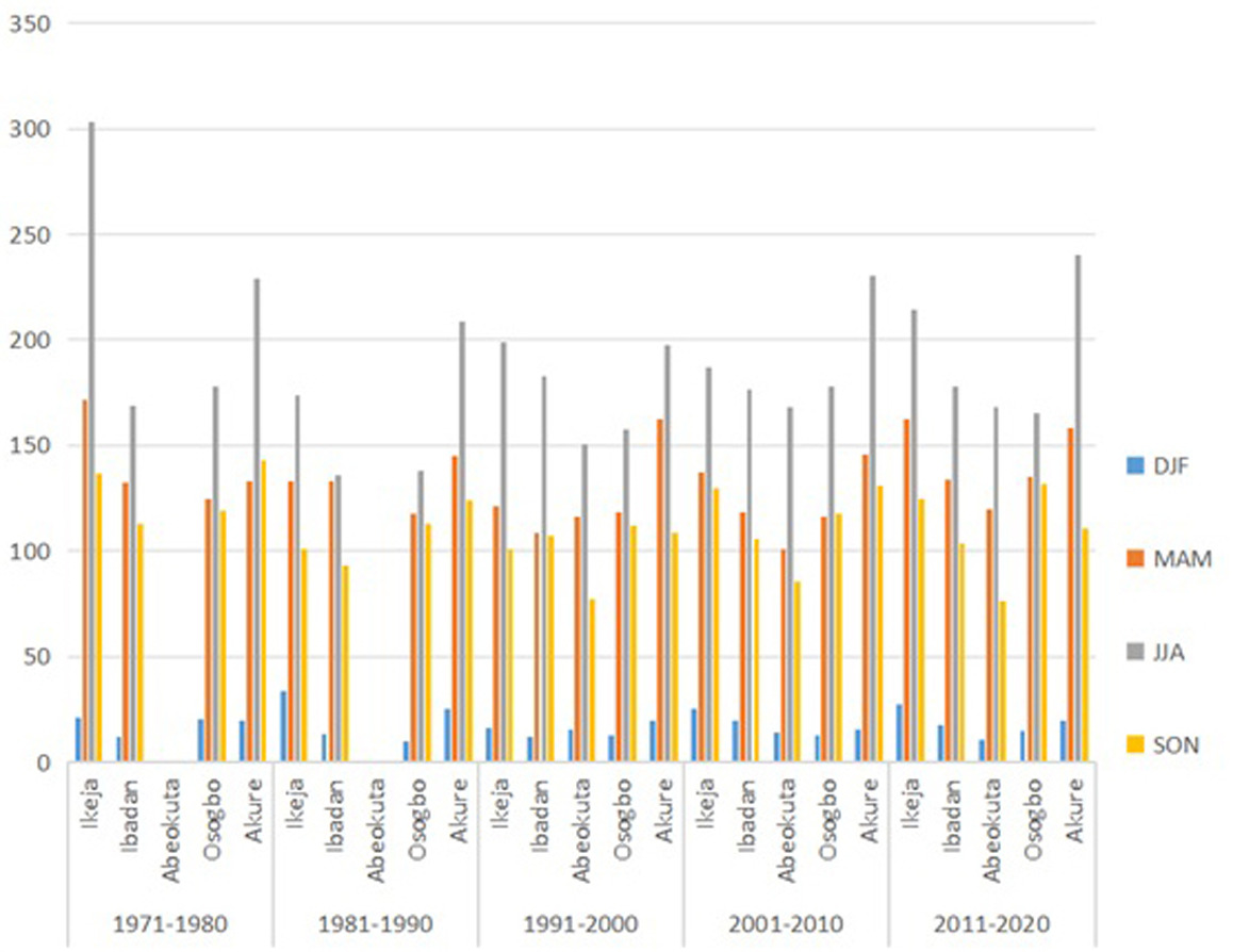
Table 1.
Mean seasonal rainfall amounts in decades between 1971-2020. Source: Author’s computation (2023).
These are dry seasons because of the local influence of the dry harmattan wind which blows via the northerly wind from the opposite direction. This accounts for the low rainfall amount recorded in most stations, especially in Ibadan at this time. Ibadan ought to receive more rainfall than the Akure and Osogbo stations because of its proximity to the Atlantic Ocean. In the June, July and August (JJA) season, the South-westerly is strengthened mainly because of the absence of the desiccating wind and it is able to push inland. This accounts for the higher rainfall amount recorded in every station as compared with the December, January and December (DJF) season.
It is important to note that during the March, April and May (MAM) season, spatial patterns of variation change slightly from the previous occurrence. Based on the record, the decade 1991-2000 was wetter than 1981-1990. Ibadan ceased to be the driest during the first two decades, especially in the seasons of DJF and MAM. However, variation in rainfall might be explained by the orographic characteristics of Akure and Osogbo, which were situated on a higher ground level. This finding is supported with the outcome of Barbro and Deliang (2003) that, on the upwind side of a mountain, precipitation increases; while less rainfall is recorded on the leeward side.
3.2. Wind flow direction and the Nigerian rainfall system between 1971-2020
The South-westerly monsoon wind was consistent with the DJF season over Ikeja, Ibadan, Akure, while the extension of strong westerly wind components pushing from the coastal area were much more prevalent in Osogbo with a relatively stable atmosphere (Fig. 3). High wind speeds, fluctuating between 4.14-4.86 m/s, was recorded in Akure. The DJF rainfall amounts of 21 mm, 12 mm, 20 mm, 19 mm were recorded for Ikeja, Ibadan, Osogbo and Akure respectively. Osogbo’s weather conditions were fairly good in the season of DJF which could be the reason for the station recording rainfall of around 20 mm in the decade.
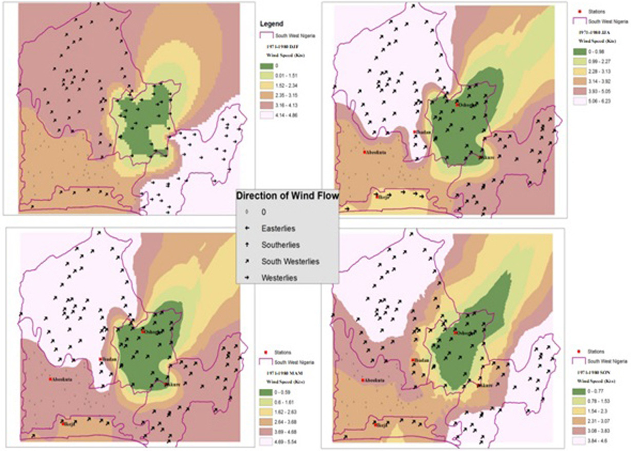
The strong South-westerly wind stream was prominent and advanced in the season of JJA, being the peak of the annual rainfall amount. In this season, Ikeja received a mean seasonal rainfall amount of 303 mm while 169 mm in Ibadan, 178 mm in Osogbo and 229 mm in Akure were recorded respectively (Tab. 1). This implies that some local weather patterns like sea breeze and urban heat island influence had contributed to the high amount of rainfall recorded in Ikeja in JJA season compared to other stations. Ayoade (1988; 2004) and Omogbai (2010) agreed with this result – that maritime air mass is prominently alert during the season of JJA – which accounts for more rainfall at this time.
Tropical westerly jet streams majorly characterized the season of MAM in all the meteorological stations. During the season, Ikeja recorded 172 mm mean seasonal rainfall amounts with 133 mm in Ibadan, 124 mm in Osogbo and 133 mm in Akure. The close proximity of Ikeja to the Atlantic Ocean with the influence of strong southerly winds and local sea breezes must have been the main reasons for the area recording a remarkable amount of rainfall in the season.
Extensive strong southerly wind flows characterized the study area with a corresponding rainfall amount of 136 mm in Ikeja, 113 mm in Ibadan, 119 mm in Osogbo and 142 mm in Akure in the season of SON. This result shows that a westerly monsoon wind was the major wind direction that explained the rainfall system of southwestern Nigeria in the first decade (1971-1980) of study. However, these meteorological stations are found to be domiciled in major cities in Nigeria. Meanwhile, high amounts of rainfall recorded in these stations are expected, as supported by Odjugo (2010) in his observation that there have been statistically significant levels of precipitation and temperatures in vast major cities in Nigeria.
The strong westerly wind flow was effective in all the seasons in the second decade (1981-1990) as shown in Figure 4. This pattern of wind flow generally affected the rainfall system of the study area with Ikeja recording a 34 mm mean seasonal rainfall amount. About 13 mm was recorded in Ibadan, 10 mm in Osogbo and 25 mm in Akure respectively. The raining season JJA was largely influenced by strong southerly components pushing from coastal areas toward the continent. Such push with high speed of wind fluctuating between 5.22-6.33 m/s in Ikeja and Ibadan created good weather conditions and high tendency for the development of eddies. This type of weather contributed remarkably to a high mean seasonal rainfall amount of 135 mm and 174 recorded in Ibadan and Ikeja. However, there are many high scrapers that obstructed the inflow of moisture laden southerly streams at any particular location. At such locations, bulk of eddies were developed and lower atmosphere were fully saturated and resulted in corresponding amount of rainfall.
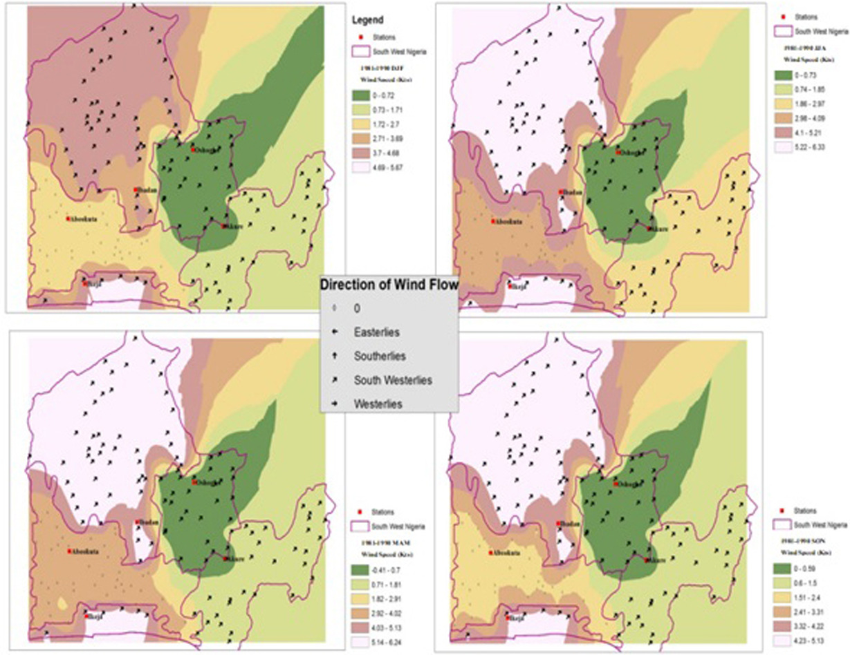
In Osogbo, a relatively stable atmosphere of 0.1-0.73 m/s wind speed was noted. The humid nature of this environment accounted for the higher levels of rainfall, though the weather condition was fairly bad because of the high pressure that characterized the area recorded with 138 mm amount of rainfall. Moreover, the convergence of direct southerly moisture flows over Akure with wind speed ranging between 0.74-1,85 m/s also affected the rainfall system of this area compared to other stations in the same season, JJA.
The season of MAM in the decade was also influenced by a tropical westerly wind with a mean seasonal rainfall amount of 133 mm recorded in Ikeja, 133 mm in Ibadan, 118 mm in Osogbo and 145 mm in Akure respectively. Akure recorded a high amount of rainfall, about 145 mm, due to the pronounced effect of the orographic nature of the area and the wind speed being relatively low (about 2.9 m/s). The SON season recorded low amounts of rainfall compared to SON of the previous decade. However, southerly wind dominated the season in all the stations with high wind speed fluctuating between 4.23-5.13 m/s in Ikeja and Ibadan. It was observed that high rates of wind speed in these stations resulted in low amount of rainfall in 100 mm in Ikeja and 93 mm in Ibadan compare to 113 mm in Osogbo and 124 mm recorded in Akure in the same SON season. The high amount of rainfall recorded during the seasons MAM and JJA, and relatively high rainfall in SON is as a result of the movement of ITD towards the northern part of the country during these seasons. Adejuwon et al. (1990) and Ayoade (1988) are in support of this, finding that ITD is the most popularly accepted medium that influences rainfall distribution in Nigeria. In other words, rain falls mostly when an area is overlain by the maritime air mass and ceases when the area is overlain by continental tropical air mass.
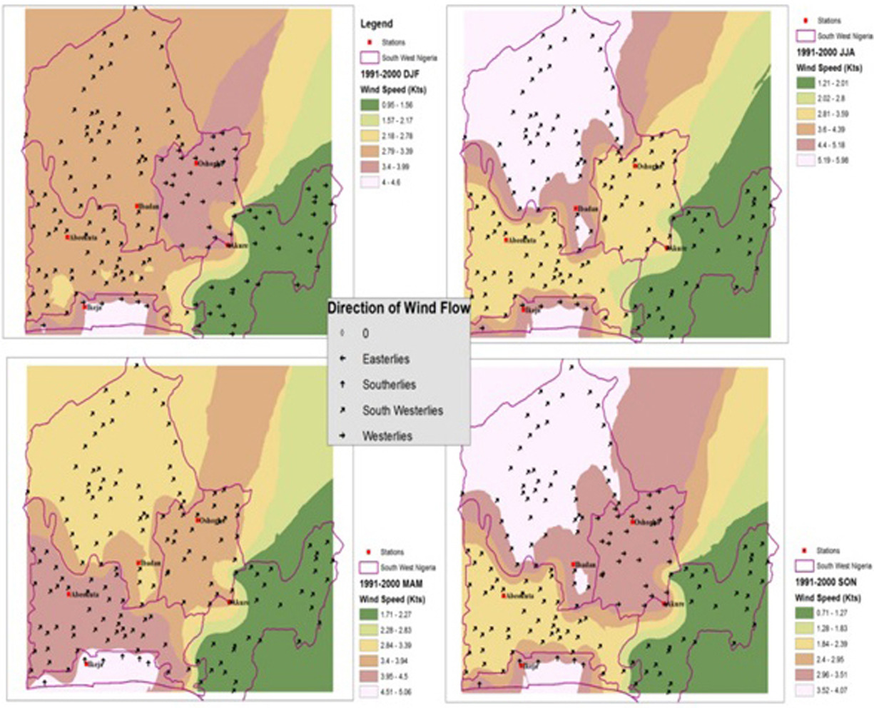
In Figure 5, it was observed that both Westerlies and South-westerly wind streams were the major wind patterns that controlled the rainfall system of the study area in the decade (1991-2000). The summer period of DJF revealed that South-westerly winds over Ibadan and Abeokuta produced mean seasonal rainfall amount of 12 mm and 16 mm. The westerly wind component over Osogbo, Akure and Ikeja recorded low amounts of mean seasonal rainfall of 13 mm, 20 mm and 17 mm respectively. The rate of wind speed in Akure was extremely low compared to other stations. This low wind speed however must have been the reason for the station recording increased amounts of rainfall. Ideally, low wind speed would always promote air convergence in the lower atmosphere.
In the season of JJA, a South-westerly air stream was very pronounced and acted to induce convective precipitation as high mean seasonal rainfall amount of 199 mm in Ikeja, 183 mm in Ibadan, 151 mm in Abeokuta, 158 mm in Osogbo and 198 mm in Akure were recorded respectively. Wind speed contributed to the development of various weather systems in this season because the low effect of the southerly moist air from the Atlantic Ocean influenced the weather pattern in Ikeja, thereby increased the rainfall amount compared to other stations that were far apart from the effect. The MAM and SON were predominantly influenced by the South-westerly monsoon wind that repeated itself from season to season.
The season being the period for rainfall onset, received a corresponding rainfall amount of 121 mm in Ikeja, 109 mm in Ibadan, 116 mm in Abeokuta, 119 mm in Osogbo and 162 mm in Akure. A kind of low pressure was created in SON toward the Atlantic Ocean, with wind speed ranging between 3.63-4.12 m/s in Ibadan and 3.14-3.63 m/s in Akure. This showed that weather condition was fairly good, and that the atmosphere was relatively stable in the season. This is the reason for the season recording a corresponding rainfall amount of 101 mm in Ikeja, 107 mm in Ibadan, 77 mm in Abeokuta, 112 mm in Osogbo and 109 mm in Akure. Wind speed was generally low in the decade compared to the last decade. However, the ITD has been shifted towards the southern part of the country whereby dry wind with easterly effect has greater influence on the rainfall system at this season. Both the temperature and wind speed are on the increase during the season of DJF because of the state of ITD. Adejuwon (1990) supported this finding with his assertion that rainfall characteristics in terms of distribution, retreat and periodicities cannot be compared with the relatively stable nature of the temperature.
This study revealed that, in Figure 6, southerly wind stream, westerly wind and South-westerly wind flows were the principal wind patterns that controlled the rainfall system of the study area in the 2001-2010 decade. Southerly wind was prevalent in Ibadan and Abeokuta in the season of DJF, MAM, JJA and SON while southerly wind over Ikeja in the season of MAM and SON produced the mean seasonal rainfall of 137 mm and 130 mm. Similarly, strong consistent westerly winds with continental air mass over Osogbo and Akure in DJF accounted for low mean seasonal rainfall amount of 13 mm and 15 mm respectively. Osogbo recorded 118 mm high amount of rainfall in SON season because of strong westerly push. Meanwhile, South-westerly wind influenced the rainfall system in JJA and MAM in all the stations with the exception of Ikeja with corresponding mean seasonal rainfall amount ranging between 100-230 mm with maximum wind speed fluctuating between 5.19-5.98 m/s in the season of peak amount of rainfall (JJA). However, the low wind speed of 0.71-1.27 m/s was recorded in SON season. In DJF, atmospheric volume was reduced and allowed the free flow of air stream especially in Ikeja, Osogbo and Abeokuta fluctuating between 4.0-4.6 m/s, 3.4-3.9 m/s and 2.79-3.39 m/s respectively.
The season of JJA revealed that extensive westerly stream had its way over the entire study area. Akure recorded substantial mean seasonal rainfall of about 146 mm because the speed of wind was very low thereby allowing the formation of rain-forming cloud. Ikeja received about 137 mm of rainfall because of the effect of local wind, e.g. the prevailing sea breeze. The low effect of the sea breeze was also noted in Abeokuta just as continental effects like relief, topography and vegetation typically influenced the rainfall system of Akure. This result is supported by Barbro and Deliang (2003): that precipitation distribution in Sweden is largely influenced by wind speed and topography.
Figure 7 showed the predominant direction of wind flows between 2001-2010 in the study area. The DJF season recorded that South-westerly wind streams were very prominent in Ikeja, Ibadan, Abeokuta and Osogbo with corresponding mean seasonal rainfall amount 28 mm, 18 mm, 11 mm and 15 mm respectively, and direct westerlies over Akure accounting for 20 mm mean seasonal rainfall. The season of JJA was the peak of maximum mean seasonal rainfall in the decade. The season was majorly controlled by South-westerly monsoon winds with a remarkable corresponding rainfall amount of 214 mm in Ikeja, 178 mm in Ibadan, 168 mm in Abeokuta, 166 mm in Osogbo and 240 mm in Akure compared to the SON season which was controlled by the South-westerly wind. It could be pointed out that the season of SON had little effect on easterly flows from the Sahara area. This easterly flow contributed to little decline in rainfall amount to 130 mm, 106 mm, 86 mm, 118 mm and 131 mm recorded in Ikeja, Ibadan, Abeokuta, Osogbo and Akure respectively compared with the JJA season in the decade.
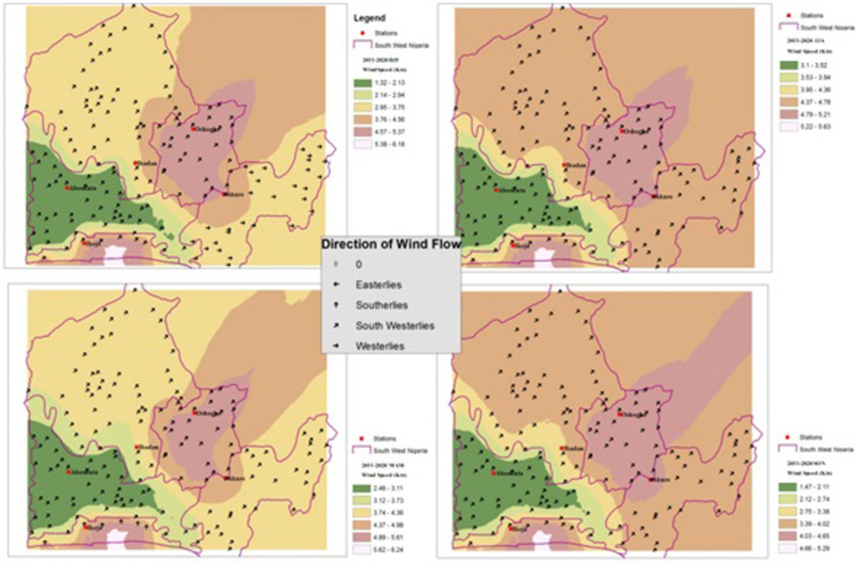
Interestingly, the MAM season recorded average mean seasonal rainfall amount due to the interception of easterly winds over this period. The decade was marked with high wind speeds in Ikeja, ranging between 5.38-6.18 m/s in DJF, 5.22-5.63 m/s in JJA, 5.62-6.24 m/s in MAM and 4.66-5.29 m/s in SON respectively. Similarly, Osogbo recorded an increasing wind speed, fluctuating between 4.57-5.37 m/s in DJF, 4.79-5.21 m/s in JJA, 4.99-5.61 m/s in MAM and 4.03-4.65 m/s in SON respectively. It thus implied that strong southerly winds exerted a great control on the rainfall system in the decade as measured with a reasonable mean seasonal rainfall amount. The decade must have recorded bountiful economic yields especially in the area of agriculture in the study area. Hsu and Guo’s (2005) report is consonant with this finding that rainfall loss rate increases when wind speed increases and rainfall intensity decreases. In other words, rainfall amount is largely affected by predominant wind speed and wind direction.
4. Conclusion
The study has examined rainfall and wind flow patterns of southwestern Nigeria from 1971 to 2020 and observed a deviation from the annual mean. Ikeja was perceived as the wettest location in the rainy season of the June, July and August (JJA) months because of the strong southerly wind and local sea breeze that generated a remarkable amount of rainfall in the season. The recorded mean seasonal rainfall amounts of 303 mm in Ikeja, followed by Akure (229 mm), Osogbo (178 mm), and Ibadan (169 mm) were indications of local weather patterns, like sea breeze influence, that usually results in rainfall variability. The South-westerly monsoon is moisture laden and, hence, a rain bearing wind, which blows inland from the Atlantic Ocean. The study also observed the weakness of the wind during the December, January and February (DJF) months due to the local influence of the dry harmattan wind that blows northerly from the opposite direction. This period of dryness has been accounted for low rainfall amount recorded in most stations. especially in Ibadan at this time.
